Table of Contents
Singapore URA Draft Master Plan 2025: New Housing Clusters, Land Rezoning & Key Transformation Areas
Singapore’s Draft Master Plan 2025, unveiled by the Urban Redevelopment Authority (URA), sets the direction for how the nation will evolve its land use, housing, and urban spaces over the next decade and beyond. With over 80,000 new homes expected to be introduced across various public and private developments, the Master Plan reflects Singapore’s proactive approach to building a more liveable, sustainable, and inclusive city, while ensuring that growth is spread out across multiple regions instead of being concentrated in the city centre.
A key feature of the plan is the rollout of new housing clusters, rezoned land parcels, and redevelopment of transitional sites throughout Singapore’s Central Area, Central Region, North, North-East, East, and West regions. Each region will see land unlocked in both mature and emerging districts, with a strong focus on integrating homes with transport, jobs, amenities, and green spaces.
In the Central Area, city-fringe locations such as Newton, Monk’s Hill, Paterson Orchard, and Pearl’s Hill have been earmarked for new residential developments that blend urban renewal with heritage preservation and greenery. The Great World and Havelock precinct is set to welcome upcoming private condominiums like River Green, Promenade Peak, Zyon Grand, and The Robertson Opus, all well-positioned near MRT connectivity and the Singapore River lifestyle corridor. At the southern gateway, Marina South is envisioned as a car-lite waterfront precinct anchored by Marina South MRT. At the same time, the Marina Bay Golf Course has been identified for long-term redevelopment to support future housing needs.
In the broader Central Region, multiple transformation areas are underway. The iconic Greater Southern Waterfront will be developed in phases, beginning with the Keppel neighbourhood cluster. Inland, residential plans have been drawn up for Dover Medway, Depot Lane, Gillman Barracks, and the former Bukit Timah Turf City, bringing homes closer to nature, education, and heritage sites. Mount Pleasant will also be developed into a thoughtfully designed public housing estate with green buffers and urban character. In the Mediapolis precinct, part of Media Circle has been rezoned to Mixed-Use (Residential with Commercial at 1st Storey) — placing new homes right beside One-North’s innovation and media hub. Similarly, land near Science Park has been safeguarded for future residential development to support the knowledge economy.
Over in the East Region, transformation continues with the creation of a new waterfront township at Bayshore, supported by two Thomson-East Coast Line stations and park connectors. Meanwhile, additional housing sites are being explored across the Tampines, Pasir Ris, and Changi corridors to accommodate future population and infrastructure needs and the upcoming Changi T5.
The North Region features several large-scale transformations, starting with the former Singapore Turf Club in Kranji, which will be redeveloped into a major mixed-use township with housing, parks, and heritage integration. Further north, Woodlands North will serve as a key cross-border node once the RTS Link to Johor Bahru opens. Sembawang Shipyard will also be transformed into a coastal residential precinct, and in Yishun, Chencharu is set for about 10,000 new homes by 2040. The Orchid Country Club in Yishun has also been identified for potential long-term housing use.
The North-East Region will see continued decentralised growth with more housing in tranquil, MRT-connected areas like Springleaf and Lentor Estate. The Defu neighbourhood, located near the upcoming Paya Lebar Airbase redevelopment, is under study to support new residential and employment opportunities, extending growth across the wider north-east corridor.
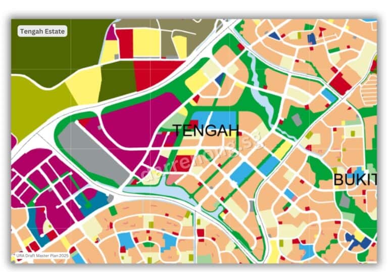
In the West Region, long-term land needs will be supported by the future redevelopment of Warren Golf & Country Club. One of the most notable developments in this region is Tengah, Singapore’s first “Forest Town.” As Tengah continues to mature with new BTO launches, the estate will soon welcome its first mixed-use private condominium at Tengah Garden Avenue, located next to the upcoming Hong Kah MRT. This marks a significant milestone in Tengah’s evolution into a fully integrated township with housing, commerce, green infrastructure, and smart transport systems.
Altogether, the Draft Master Plan 2025 highlights Singapore’s forward-looking approach to creating vibrant, well-connected, and resilient neighbourhoods across every region. For property buyers, sellers, upgraders, and investors, these upcoming transformation zones provide a timely glimpse into where future opportunities may lie — and how the real estate landscape is set to evolve in the years ahead.
Let’s dive into the key transformation clusters now.
Central Area Transformation: URA Draft Master Plan 2025
The Central Area Transformation under the URA Draft Master Plan 2025 represents a comprehensive and forward-looking vision for Singapore’s historic and economic core.
This plan aims to shape the Central Area into a vibrant, inclusive, and sustainable district where residents can live, work, and play in a well-connected, green, and culturally rich environment.
Key strategies include the creation of mixed-use precincts, car-lite neighbourhoods, and integrated community hubs, all supported by enhanced pedestrian and cycling networks.
The transformation places strong emphasis on preserving heritage sites and natural spaces while preparing the city centre for climate resilience and evolving demographic needs. Through these initiatives, the Central Area is set to remain the beating heart of Singapore, seamlessly blending modern urban living with its unique historical and cultural identity.

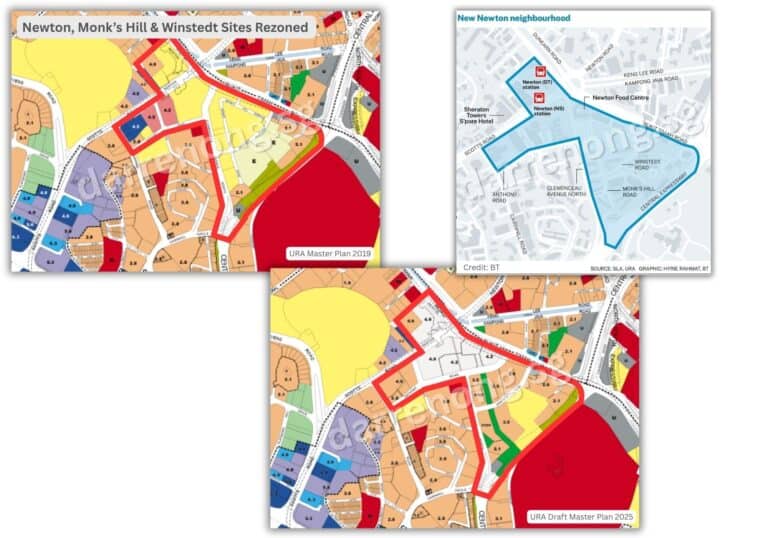
Newton Monk’s Hill Cluster
Positioned next to Newton MRT station and the iconic Newton Food Centre, the Newton & Monk’s Hill Cluster will be developed into a high-density “urban village” comprising around 5,000 new private residences, distributed across Newton Circus, Scotts Road, and Monk’s Hill.
Urban design guidelines will ensure that future developments are introduced sensitively, preserving the area’s established character. A key highlight is the transformation of Monk’s Hill Road into a linear park flanked by mature trees and conserved heritage buildings, enhancing pedestrian connectivity and community spaces.
The cluster will also feature landscaped public spaces, vibrant street-level activity, and strong access to both the Downtown Line and North-South Line. This new neighbourhood will offer city-edge living within minutes of Orchard, Novena, and the CBD, supporting a walkable, green, and socially cohesive environment.
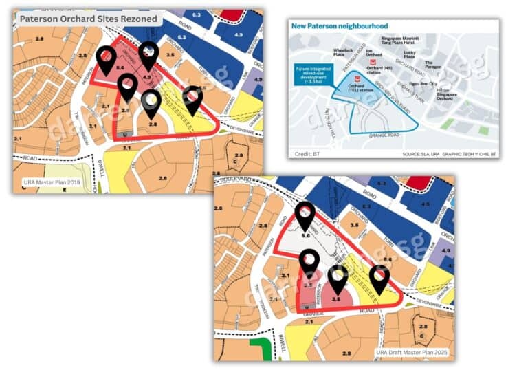
Paterson Orchard Cluster
Located just off Orchard Road, the Paterson Orchard Cluster is set to introduce about 1,000 new private homes, including those within a new integrated mixed-use development directly above Orchard MRT station.
This development will combine residential units with retail, dining, and office spaces, creating a dynamic “vertical village” that enhances the precinct’s vibrancy and convenience. A shop-lined pedestrian route will extend from Orchard MRT towards River Valley, improving walkability and urban connectivity.
New cycling paths will link Paterson Road to the “inner ring identity corridor,” encompassing heritage roads such as Tiong Bahru Road, Scotts Road, and Balestier Road.
These enhancements will support active mobility, celebrate local character, and reinforce Orchard’s status as a premier live-work-play district in the Central Area.
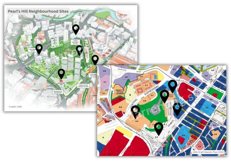
Pearl’s Hill Neighbourhood
The Pearl’s Hill neighbourhood is poised for a significant transformation while retaining its distinctive hilltop charm and heritage significance. Located next to Outram Park MRT and Chinatown, the precinct will be rejuvenated with around 6,000 new homes, including a mix of public and private housing and serviced apartments to meet diverse needs.
A new mixed-use integrated development above Outram Park MRT will act as a vibrant gateway into the area. Pearl’s Hill will be designated a car-lite district supported by an extensive active mobility network featuring elevated walkways and pedestrian-friendly paths, linking key green spaces such as Pearl’s Hill City Park, Fort Canning Park, Chinatown, and Robertson Quay.
Architectural designs will incorporate terraced buildings and stepped forms following the hill’s natural slope, complemented by sky terraces, rooftop gardens, and curated public spaces to foster social interaction and biodiversity. Adaptive reuse of heritage sites like the former police barracks, part of the Police Heritage Trail, will enrich the precinct’s cultural identity.
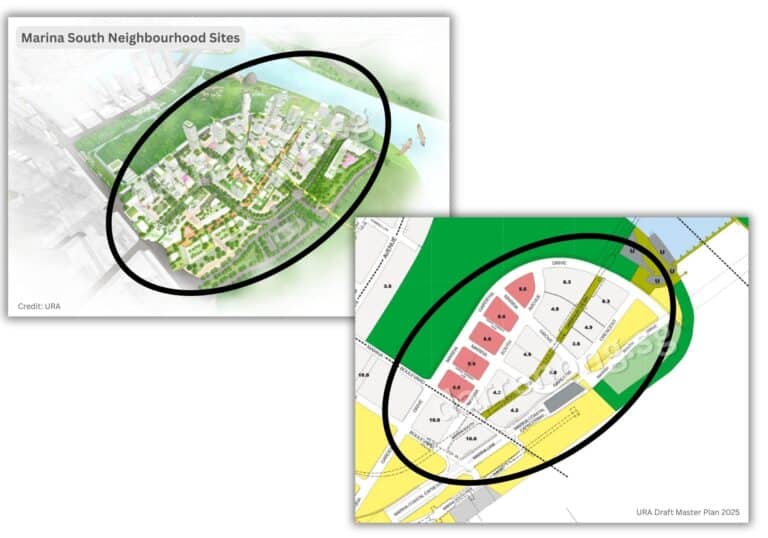
Marina South Neighbourhood Transformation
Marina South is envisioned as a flagship waterfront district and a model for next-generation city living. Spanning approximately 45 hectares beside Gardens by the Bay, it will offer more than 10,000 new homes within a lush, mixed-use neighbourhood designed around sustainability and community.
The precinct will feature an extensive network of green spaces, pedestrian-friendly streets, and vibrant public plazas, embodying the “10-minute neighbourhood” concept where daily amenities, parks, shops, and MRT connectivity are within a short walk.
Environmental modelling has informed the layout to optimise wind flow and mitigate urban heat island effects. Streets will be shaded with biodiversity-friendly plantings, and rooftop gardens will enhance ecological connectivity from Gardens by the Bay to the coast.
All developments will meet stringent environmental standards, including BCA’s Green Mark Platinum Super Low Energy rating, integrating sustainable solutions like food waste composting and rain gardens. Marina South’s strategic location and design will make it one of Singapore’s most iconic and future-ready residential districts.
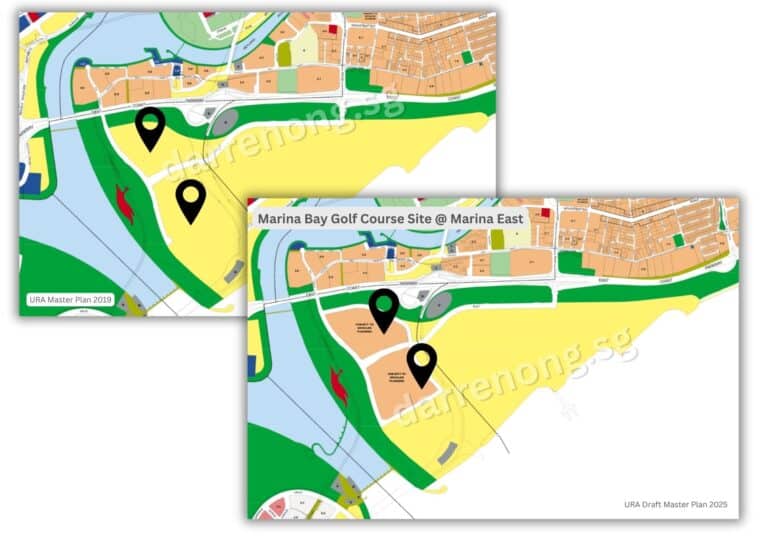
Marina Bay Golf Course Site (Future Transformation)
With the lease expiry of the Marina Bay Golf Course in July 2024, this prime waterfront site has been earmarked for a major future redevelopment under URA’s long-term vision. Strategically located along Marina Bay’s edge, the site offers immense potential for high-density, mixed-use development featuring residential towers with panoramic skyline views.
The transformation will integrate lush park spaces, active mobility corridors, and community amenities designed to support a car-lite lifestyle. Connectivity to Marina South, Bay East Garden, and Gardens by the Bay will be enhanced, creating a seamless waterfront urban environment. As one of the last major land parcels available in the city core, this redevelopment represents a rare opportunity to redefine Singapore’s urban waterfront for future generations.
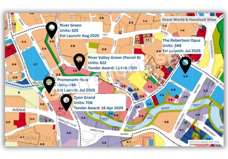
Great World & Havelock Neighbourhoods
The Great World and Havelock precincts remain key focal points for the upcoming private residential supply. Across five plots, including River Green, Promenade Peak, Zyon Grand, The Robertson Opus, and River Valley Green (Parcel B), nearly 2,800 new private homes will be introduced.
These developments are strategically positioned near Great World and Havelock MRT stations on the Thomson-East Coast Line, providing excellent connectivity.
The precinct benefits from proximity to the Singapore River, Robertson Quay, Orchard Road, and the CBD, making it attractive for residents seeking vibrant city living with access to lifestyle, dining, and recreational amenities. The ongoing residential growth supports the Central Area’s evolution as a well-connected, liveable urban core.
Key Features and Urban Strategies
- Car-lite and Walkable Districts: All new neighbourhoods will prioritise active mobility, with extensive pedestrian and cycling networks, car-lite zones, and proximity to multiple MRT lines.
- Mixed-Use and Integrated Developments: Residential, retail, office, and community spaces will be blended to create vibrant, self-sufficient precincts.
- Green and Blue Networks: Enhanced park connectors, linear parks, rooftop gardens, and waterfront promenades will promote biodiversity, recreational opportunities, and urban cooling.
- Heritage and Identity: Conservation of historic buildings, adaptive reuse of heritage sites, and curated public spaces will preserve and celebrate the Central Area’s unique character.
- Sustainability and Resilience: Developments will meet high environmental standards, incorporate climate-adaptive design, and support Singapore’s “City in Nature” vision.
Summary Table: Central Area Transformation Highlights
| Neighbourhood / Cluster | Key Features & Plan |
|---|---|
| Newton Monk’s Hill Cluster | 5,000 private homes, urban village, linear park, heritage integration, strong MRT connectivity |
| Paterson Orchard Cluster | 1,000 private homes, mixed-use above Orchard MRT, shop-lined pedestrian route, cycling corridors |
| Pearl’s Hill Neighbourhood | 6,000 homes (public/private), car-lite, integrated with Outram Park MRT, heritage and green spaces |
| Marina South Neighbourhood | 10,000+ homes, 45-ha mixed-use, “10-minute neighbourhood”, eco-friendly, high sustainability |
| Great World & Havelock | Close to 2,800 private homes, multiple new launches, near MRT, riverfront, lifestyle amenities |
| Marina Bay Golf Course Site | Future mixed-use, high-density, waterfront homes, park spaces, last major city-core land parcel |
Central Region Transformation: URA Draft Master Plan 2025
The Central Region, extending beyond Singapore’s historic city core, is entering a new phase of transformation that fuses liveability, heritage, and sustainability. Under the Draft Master Plan 2025, this region will see multiple housing and mixed-use developments introduced across precincts steeped in character—from innovation zones to green sanctuaries—where urban living beckons, history is celebrated, and nature is always near.
Among the highlights: Greater One-North continues to grow as a world-class innovation hub, Bishan 2.0 reimagines a well-loved town into a revitalised regional centre, Bukit Timah Turf City will welcome heritage-inspired hillside living, and Kallang Alive will extend Singapore’s sports and recreation offerings into a vibrant lifestyle district.
Across each of these areas, URA’s vision is clear—to provide vibrant city living for all, anchored by green trails, lifestyle amenities, and inclusive public spaces. Residents can look forward to cherished tales and green trails, whether it’s walking through historic corridors, enjoying rooftop gardens, or exploring new parks along former military estates.
With upcoming housing zones near MRT lines, green buffers around heritage estates, and land safeguarded near business and research parks, the Central Region will continue to evolve into a dynamic landscape where live-work-play meets Singapore’s next chapter of urban renewal.
Greater one-north Transformation (Dover-Medway & Mediapolis)
Greater One-North is set to become a flagship innovation district, seamlessly integrating the Dover-Medway neighbourhood and Mediapolis/Media Circle. The Dover-Medway precinct will introduce about 6,000 new public and private homes, closely connected to major institutions such as the National University of Singapore (NUS), Singapore Polytechnic, and Anglo-Chinese School (Independent). Over time, some institutions like the Singapore Institute of Technology (SIT) and United World College of South East Asia (UWCSEA) will relocate, freeing up land for new housing, parks, and amenities. Residents will benefit from proximity to the One-North business cluster, Kent Ridge, and One-North MRT stations, and a network of parks and community facilities.
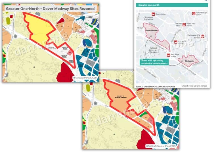
The adjacent Mediapolis/Media Circle area will add up to 5,000 new private homes, integrated with commercial spaces at the first Storey. This supports Singapore’s vision as a global media and tech hub, with green corridors, lifestyle amenities, and direct access to One-North Park, the Wessex estate, and the Rail Corridor. The transformation creates a vibrant live-work-learn environment, with active mobility networks and a strong focus on sustainability and innovation.

Bishan 2.0
Bishan is on the cusp of an exhilarating reinvention as Singapore’s newest sub-regional centre. “Bishan 2.0” will inject fresh energy into this beloved heartland, transforming it into a lively urban destination where sleek mixed-use developments, modern workplaces, and next-generation amenities converge. Picture a town centre buzzing with new life—expanded retail, dining, and entertainment options set amidst lush green spaces and active mobility networks.
The transformation will introduce dynamic public spaces and social nodes, inviting the community to gather, celebrate, and connect. Enhanced walkability, new cycling routes, and refreshed parks will make it easier than ever to explore Bishan’s charms, while innovative urban design ensures accessibility, inclusivity, and future-readiness. With its strategic location and renewed energy, Bishan 2.0 is poised to become a thriving hub that rivals Singapore’s most sought-after city-fringe districts, setting a new benchmark for liveability and urban excitement.
Bukit Timah Turf City Transformation
The transformation of the former Bukit Timah Turf Club marks one of Singapore’s most ambitious urban redevelopment projects, set to deliver between 15,000 and 20,000 new public and private homes—the first public housing to be built in Bukit Timah in nearly 40 years. This high-density hillside estate will be transformed in phases over the next 20 to 30 years, following a sensitive, long-term strategy that integrates homes, heritage, greenery, and community spaces within a cohesive urban design.
Located near Sixth Avenue MRT and the upcoming Cross Island Line (CRL) station, the new estate will champion a car-lite lifestyle, with walkability, cycling paths, and green corridors woven throughout the precinct. The master plan places strong emphasis on heritage conservation, with selected historic buildings—including the iconic former grandstand—being retained and repurposed for new community or lifestyle uses. A new central oval will serve as a vibrant focal point for gatherings and recreation, while stepped building forms will respect the site’s natural undulating terrain.
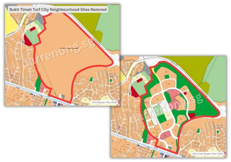
Much of the Eng Neo Avenue Forest and Bukit Tinggi will be preserved, safeguarding biodiversity and providing natural buffers between neighbourhoods. The estate will adopt a “10-minute neighbourhood” concept, ensuring that most residents are within a short walk of amenities, parks, and transport nodes. Four distinct sub-precincts will each offer their own character, inclusive public spaces, and a variety of housing options to cater to different lifestyle needs.
Enhanced connectivity will be a hallmark of the new Bukit Timah Turf City, with cycling paths and walkways linking the estate to the Rail Corridor and Bukit Timah Nature Reserve. Altogether, the precinct is envisioned as a serene hillside sanctuary that honours its equestrian past and sets a new benchmark for integrating heritage and sustainability in Singapore’s urban living.
Kallang Alive
Get ready for Kallang Alive—a game-changing transformation that will elevate Kallang into Singapore’s ultimate sports, recreation, and lifestyle district. The precinct is set to pulse with excitement as new world-class sports facilities, entertainment venues, and waterfront attractions come to life. Imagine cheering at major sporting events, catching concerts under the stars, or unwinding at vibrant waterfront promenades—all just minutes from the city centre.
Kallang Alive will be a magnet for active lifestyles, with extensive park connectors, cycling trails, and open spaces that invite everyone to play, move, and relax. The district’s connectivity will be supercharged, linking seamlessly to neighbouring communities and the heart of Singapore. With its bold vision and dynamic offerings, Kallang Alive promises to be a destination where energy, diversity, and urban vibrancy converge, making it the go-to place for unforgettable experiences and everyday enjoyment.
Greater Southern Waterfront (Keppel Cluster)
As part of Singapore’s long-term strategy to decentralise growth and create new urban frontiers, the Greater Southern Waterfront (GSW) is one of the nation’s most ambitious transformation projects, stretching from Pasir Panjang to Marina East. The first phase will begin at the Keppel precinct, where the former Keppel Club site will be progressively redeveloped into a vibrant waterfront residential district seamlessly connected to the Rail Corridor, Southern Ridges, and future coastal parks.
This precinct will eventually introduce over 9,000 new homes—a mix of public and private housing—with the Keppel Cluster leading the way in transforming former port and industrial land into liveable waterfront communities. Residents can look forward to abundant greenery at their doorstep, direct access to the Southern Ridges, and connectivity to major lifestyle attractions such as Sentosa and the future Pulau Brani development.
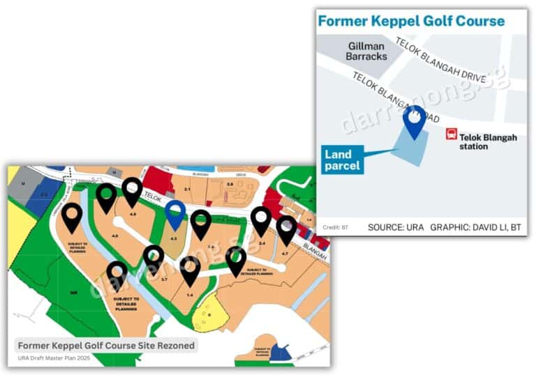
A major milestone is the launch of the first 1,000 BTO flats at the former Keppel Club site, scheduled for October 2025. This marks the opening of the waterfront to a diverse community and the introduction of public housing in this highly sought-after locale. The development will prioritise a car-lite, walkable environment, with about 20% of the site set aside for parks and open spaces, including four planned green corridors running through the estate. Residents will also benefit from proximity to Labrador Park and Telok Blangah MRT stations, as well as continuous waterfront promenades and new park connectors linking West Coast Park to Marina East.
The transformation of the Keppel Cluster exemplifies URA’s vision for green, inclusive, and heritage-sensitive neighbourhoods—bringing city living closer to nature and supporting Singapore’s next chapter of urban renewal.
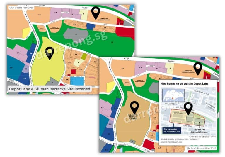
Depot Lane & Gillman Barracks Rezoned Sites
The Depot Lane and Gillman Barracks Cluster, located along Bukit Merah, is set for transformation into a vibrant city-fringe neighbourhood that blends new housing, heritage, and green spaces. Under the Draft Master Plan 2025, the existing Depot Lane industrial estate will be cleared and returned to the state by the end of 2025, paving the way for residential redevelopment on its 7.3-hectare site. The area’s development intensity will be guided by detailed planning and evaluation as it transitions from industrial to residential use.
Adjacent Gillman Barracks, a former British military camp now known for its arts and cultural precinct, is recognised for its rich heritage, with historic structures and military insignia still present within the secondary forest. URA’s plans call for the sensitive integration of new public and private housing, while preserving and adaptively reusing select heritage buildings. The cluster will benefit from proximity to Labrador Nature Reserve, Telok Blangah Hill Park, and Circle Line MRT stations such as Labrador Park and Telok Blangah, offering residents excellent access to both nature and transport. New community amenities, green connectors, and park trails will be introduced to promote active mobility and enhance liveability. By integrating creative reuse of heritage buildings with greenery and housing, this precinct exemplifies Singapore’s approach to evolving city-fringe sites into inclusive, sustainable, and well-connected urban neighbourhoods.
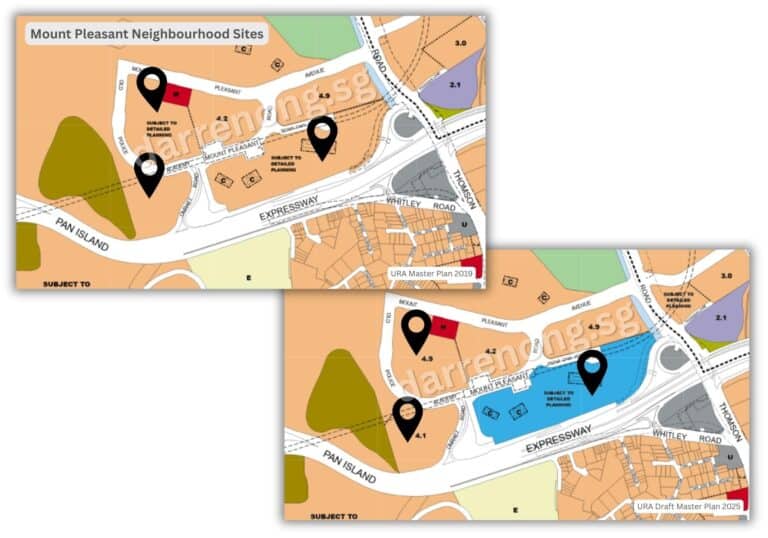
Mount Pleasant Neighbourhood Transformation
Once home to the Old Police Academy, the Mount Pleasant neighbourhood is set to be transformed into a thoughtfully planned public housing estate that celebrates its historic roots while embracing modern urban living. Located near Mount Pleasant MRT station on the Thomson-East Coast Line and close to Novena, the future neighbourhood will eventually offer around 5,000 new public housing units, supported by a neighbourhood centre, green spaces, and a community park.
The development will conserve and integrate selected buildings of the Old Police Academy into its urban fabric, potentially repurposing them as community facilities or heritage galleries that reflect the site’s storied past. The new estate will also feature green buffers, sky terraces, stepped building forms, and elevated pedestrian paths to create a walkable, liveable environment and seamless connection with surrounding nature. In line with URA’s environmental and biodiversity goals, two out of three natural streams flowing through the estate will be fully conserved, with part of the third also retained due to its richer biodiversity. These water features, along with tree-lined trails and community gardens, will offer residents access to nature while supporting habitat continuity for local flora and fauna.
Altogether, Mount Pleasant is envisioned as a heritage-inspired, green public housing precinct—one that provides quality homes while thoughtfully preserving the character of one of Singapore’s most historically significant hilltop sites.
South Buona Vista Road (Science Park II Vicinity)
In the Draft Master Plan 2025, a parcel of land along South Buona Vista Road, near the intersection with Zehnder Road and adjacent to Science Park II, has been rezoned from business park to residential use. This marks a strategic shift to address future housing needs in a well-connected, city-fringe location at the heart of Singapore’s vibrant R&D and education belt.
The site is situated directly beside Science Park II, within the larger western innovation cluster that includes leading institutions such as the National University of Singapore (NUS) and National University Hospital (NUH). Its proximity to Kent Ridge MRT station, West Coast Highway, and major employment and healthcare nodes makes it an ideal location for new homes that offer seamless connectivity to jobs, education, and medical services.
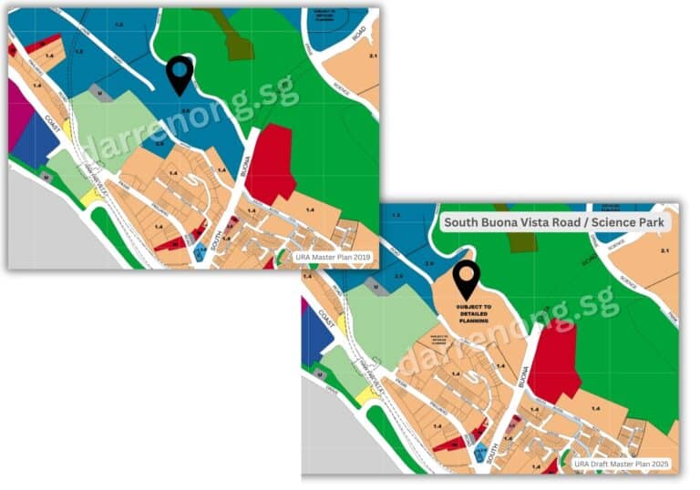
The transformation is expected to bring new private residential developments supported by green connectors, car-lite infrastructure, and walkable community amenities. This supports Singapore’s broader vision to create live-near-work precincts, reducing commute times and fostering integrated, sustainable lifestyles, particularly for talents in the science, technology, and healthcare sectors.
Summary Table: Central Region Transformation Highlights
| Neighbourhood / Cluster | Key Features & Plan |
|---|---|
| Greater one-north (Dover-Medway & Mediapolis) Transformation | 6,000 new homes in Dover-Medway and ~5,000 in Mediapolis; integrated with NUS, Singapore Polytechnic, ACS (I); vibrant innovation, research, and media hub; new parks and amenities; active mobility focus. |
| Bishan 2.0 | Sub-regional centre; new offices, retail, polyclinic, hawker centre, and transport hub; expanded amenities and green spaces; dynamic public spaces and improved connectivity; urban excitement and inclusivity. |
| Bukit Timah Turf City Transformation | 15,000–20,000 new homes (first public housing in Bukit Timah in 40 years); phased, heritage-sensitive hillside living; preserved forests, “10-minute neighbourhood” concept, car-lite, green connectivity. |
| Kallang Alive | Major sports, recreation, and lifestyle hub; new world-class facilities, waterfront promenades, park connectors, and entertainment venues; supercharged connectivity and vibrant urban lifestyle. |
| Greater Southern Waterfront (Keppel Cluster) | Over 9,000 new homes (public and private); waterfront living; first 1,000 BTO flats in Oct 2025; direct access to Rail Corridor, Southern Ridges, Sentosa, and future Pulau Brani; 20% green/open spaces. |
| Depot Lane & Gillman Barracks Site Rezoned | 7.3-ha Depot Lane site rezoned for housing; Gillman Barracks to blend new homes with heritage and arts; proximity to Labrador Nature Reserve, Telok Blangah Hill Park, and Circle Line MRT; green connectors. |
| Mount Pleasant Neighbourhood Transformation | 5,000 new public homes; conservation and adaptive reuse of Old Police Academy buildings; green buffers, sky terraces, and conserved streams; heritage-inspired, nature-integrated hilltop precinct. |
| South Buona Vista Road (Science Park II Vicinity) | Rezoned from business park to residential; next to Science Park II, NUS, NUH, Kent Ridge MRT; new private homes with green connectors and car-lite infrastructure; live-near-work for R&D and healthcare talents. |
East Region Transformation: URA Draft Master Plan 2025
The East Region of Singapore is evolving into a vibrant and future-ready district, distinguished by its strong focus on liveability, connectivity, and coastal charm. With major transformation areas such as Bayshore, Tampines North and South, Pasir Ris, Changi, and the future Paya Lebar Air Base redevelopment, the East will feature new housing enclaves, enhanced transport nodes, and lifestyle precincts that celebrate both urban innovation and heritage identity. Here, where urban living beckons, history is celebrated, and nature is always near, the East Region will be defined by smart, car-lite communities, abundant recreational spaces, and inclusive residential environments that offer something for everyone.
From the highly anticipated Changi Airport Terminal 5 and the rejuvenation of Tampines North and South, to the transformation of Pasir Ris, Loyang, and visionary developments like Long Island off the East Coast and Changi, the East is positioning itself as a place where people can truly live, work, and play. Residents and visitors alike will enjoy lush parks, scenic coastal walkways, and world-class infrastructure, making the East Region a dynamic and desirable destination for generations to come.

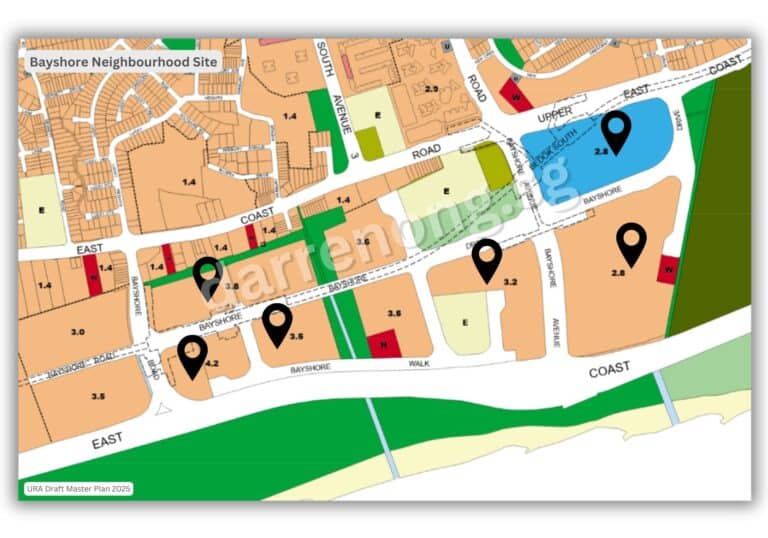
Bayshore Cluster – A Waterfront Urban Village
Bayshore is set to emerge as Singapore’s next iconic waterfront town, seamlessly blending nature, connectivity, and vibrant community living. This 60-hectare precinct, situated beside East Coast Park and served by both Bayshore and Bedok South MRT stations, will introduce approximately 12,500 new public and private homes. Designed as a car-lite estate, Bayshore will offer residents seamless access to cycling and walking paths, tree-lined promenades, and a thoughtfully planned network of amenities—all within a short stroll from home. At the heart of the estate, Bayshore Street will form a lively 1-kilometre community spine lined with cafes, shops, and community facilities. At the same time, courtyard-style housing clusters will foster interaction through ground-level playgrounds, groceries, and senior and childcare services.
Residents will also benefit from direct connectivity to East Coast Park via a new landscaped bridge, as well as a 3-hectare central park and a linear park featuring heritage seawalls and coastal-themed playgrounds. Future-ready infrastructure, such as autonomous vehicle lanes and extensive cycling networks, will connect Bayshore to Bedok and the Round Island Route, creating a highly walkable, sustainable, and inclusive waterfront lifestyle for all.
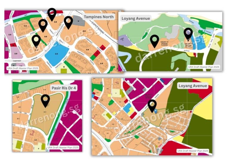
Tampines North/South, Pasir Ris & Loyang: Heartland Reinvented
The heartlands of Tampines North and South, Pasir Ris, and Loyang are undergoing a remarkable transformation to meet the needs of a growing and diverse population. Tampines North alone is projected to yield up to 21,000 new homes when fully developed, making it one of the largest upcoming public housing estates in the East. These new homes will be complemented by integrated community hubs, polyclinics, nursing homes, and enhanced green spaces, ensuring that residents enjoy a high quality of life. The rejuvenation of Sungei Tampines with rain gardens, lookout decks, and a garden bridge will further promote outdoor living and environmental sustainability.
Pasir Ris is also being revitalised as a premier coastal town, with new housing, a refreshed town centre, an integrated transport hub, and expanded park connectors and recreational spaces. Loyang will see additional homes and amenities, supported by improved connectivity through new MRT stations such as Pasir Ris East on the Cross Island Line. These precincts are set to offer a wide variety of home types, car-lite mobility, and vibrant community spaces, truly embodying the vision of a “town within a park.”
Within Pasir Ris, along Jalan Loyang Besar / Pasir Ris Drive 4, a forested plot beside Ripple Bay and Seastrand, near Jalan Loyang Besar and Pasir Ris Drive 4, has been earmarked in the URA Master Plan as a potential site for future homes. While no official launch date or detailed plans have been announced, this area remains zoned for residential use. It is under study as part of the government’s ongoing efforts to rejuvenate Pasir Ris and provide more housing. Any eventual development is expected to be sensitively integrated with the surrounding green spaces and recreational amenities, reinforcing the town’s identity as a lush, nature-centric residential destination.
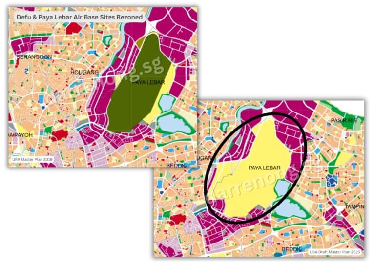
Defu & Paya Lebar Air Base: A New Generation Town
The relocation of Paya Lebar Air Base (PLAB), targeted for completion around 2030, will unlock approximately 800 hectares of land—an area comparable to Bishan, Ang Mo Kio, and Toa Payoh combined. This transformation is expected to yield up to 150,000 new homes, both public and private, making it one of the largest future residential precincts in Singapore. The new town will feature integrated housing, commercial, and business spaces, as well as extensive green corridors and a central park along the former runway.
Residents can look forward to new schools, healthcare, and community amenities, all seamlessly connected by new MRT stations and road links. Key elements of the airbase’s heritage, such as the iconic runway and selected hangars, will be preserved and repurposed as community spaces or heritage galleries, giving the town a unique identity while supporting Singapore’s long-term housing and economic needs.
Long Island: Singapore’s Visionary Coastal Frontier
Long Island represents a bold, forward-looking concept that could reshape Singapore’s southern coastline. If implemented, this visionary project would reclaim about 800 ha of land off East Coast Park, serving multiple national needs. Long Island would provide robust coastal protection against rising sea levels and flooding, while also creating a new freshwater reservoir to enhance Singapore’s water resilience.
Beyond climate adaptation, it could introduce new waterfront parks, beaches, and leisure attractions, expanding public access to blue and green spaces. There is also potential for new residential precincts, offering sea views and direct access to recreational amenities. While still under study, Long Island exemplifies Singapore’s commitment to innovative land use and climate resilience, ensuring the East remains vibrant and liveable for generations.
Changi City & Changi Business Park: The Eastern Economic Powerhouse
Changi City and Changi Business Park are rapidly evolving into the economic heart of the East, complementing the expansion of Changi Airport and the upcoming Terminal 5. These precincts already host a thriving ecosystem of aviation, logistics, technology, and financial services companies, and are poised for further growth with new business spaces and amenities.
The vision is to create an integrated live-work-play environment, with new residential developments enabling professionals to live close to work, reducing commute times, and fostering a vibrant, mixed-use community.
With world-class connectivity to Changi Airport, Singapore Expo, and major expressways, Changi City will also feature enhanced green spaces, waterfront promenades, and leisure facilities, making it a destination for both work and relaxation. As these precincts expand, they will anchor Singapore’s Eastern Gateway, driving economic growth and offering a high quality of life for residents.
Changi: Singapore’s Eastern Gateway
Changi is being reimagined as Singapore’s premier gateway to the world, anchored by the future Changi Airport Terminal 5 (T5). The area will see enhanced connectivity with new MRT stations and road links, supporting the expansion of aviation and logistics industries and the introduction of new residential developments in a carefully calibrated manner. Alongside economic growth, Changi will offer new parks, waterfront trails, and recreational spaces, ensuring a balanced and vibrant environment for both residents and workers.
Recreation, Mobility & Connectivity
Summary Table: East Region Transformation Highlights
| Neighbourhood / Cluster | Key Features & Plan |
|---|---|
| Bayshore | 12,500 new homes; car-lite, walkable estate; 1-km community spine; courtyard clusters; direct access to East Coast Park; central and linear parks; future-ready infrastructure. |
| Tampines North / South | Up to 21,000 new homes in Tampines North; new polyclinics, nursing homes, integrated hubs; enhanced Sungei Tampines; improved green spaces and connectivity. |
| Pasir Ris & Loyang | New housing, park connectors, mixed-use developments, upgraded amenities, Pasir Ris East MRT, “town within a park” identity, future housing under study at Jalan Loyang Besar/Pasir Ris Drive 4. |
| Long Island | 800-ha reclamation under study; coastal protection, freshwater reservoir, new parks, future homes, and recreation; climate resilience. |
| Defu & Paya Lebar Air Base | Relocation by 2030; 800-ha freed up; up to 150,000 new homes; integrated town with parks, heritage, and new amenities; new transport links. |
| Changi City & Business Park | Economic powerhouse, business and innovation hub, new live-work-play developments, world-class connectivity, enhanced green and leisure spaces. |
| Changi (Gateway) | Terminal 5 anchor; enhanced connectivity; new aviation, logistics, and residential precincts; new parks and recreation. |
| Recreation & Mobility | Expanded cycling/green networks; new leisure hubs; rustic trails at Changi Point; 5 new MRT stations (CRL, TEL) for the East. |
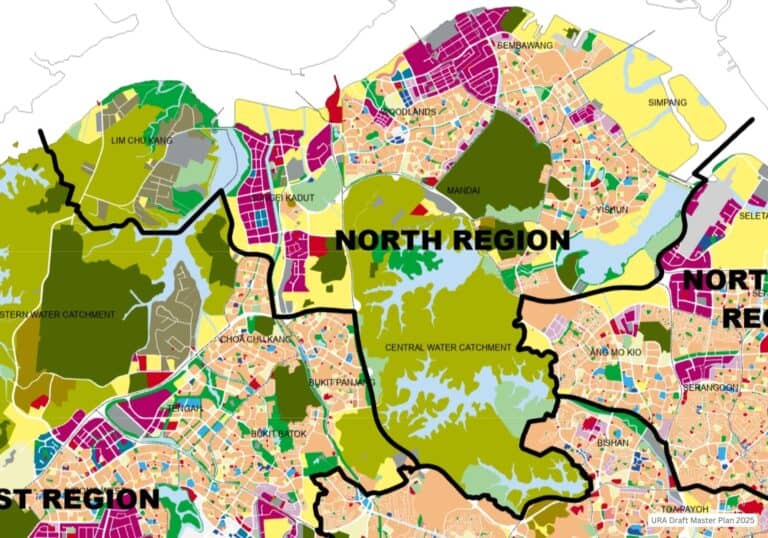
North Region Transformation: URA Draft Master Plan 2025
The North Region is on the cusp of a remarkable transformation, anchored by major nodes such as Woodlands Regional Centre, Sembawang Shipyard, the future Kranji housing estate at the former Singapore Turf Club, the upcoming integrated residential district at Chencharu, and the future redevelopment of the Orchid Country Club in Yishun. This region is set to offer an appealing blend of liveable neighbourhoods, economic opportunities, and seamless connectivity to the city and Malaysia, all while preserving its distinctive green and coastal character.
With a development strategy that balances growth and sustainability, the North will see new homes, vibrant community spaces, and lifestyle destinations emerge alongside revitalised existing sites. The transformation is designed to complement the region’s natural surroundings, ensuring that new precincts—such as Chencharu and the rezoned Orchid Country Club—are thoughtfully integrated with parks, water bodies, and heritage landmarks.
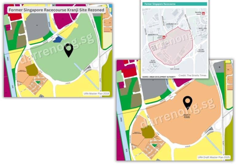
Former Singapore Turf Club – Kranji Future Transformation
The site of the former Singapore Turf Club at Kranji will be redeveloped into a major new housing estate, with around 14,000 new public and private homes planned.
This precinct will be closely integrated with the Kranji Nature Corridor, providing residents with access to parks, open community spaces, and waterways such as Sungei Mandai and Sungei Pang Sua.
The transformation will draw inspiration from the area’s rustic and equestrian heritage, with plans for green corridors, lifestyle attractions, and public spaces that reflect the site’s history as a racecourse. With direct links to Kranji MRT and upcoming infrastructure enhancements, the estate will offer a rare blend of countryside charm and modern convenience.
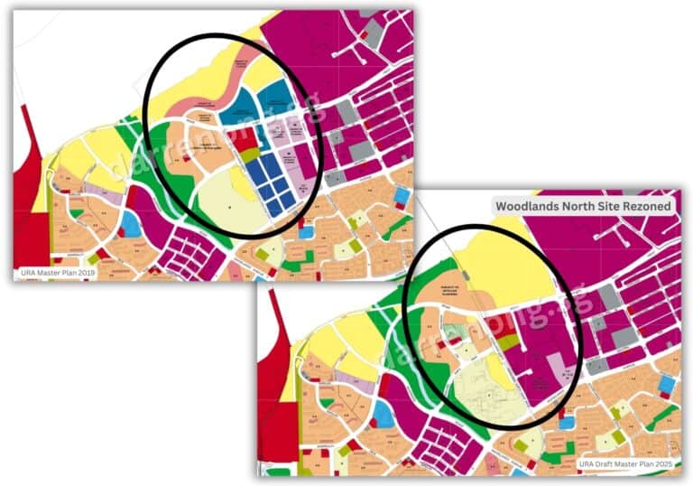
Woodlands North – New Housing Zones and Regional Centre
Woodlands North is set to evolve as a key part of the Woodlands Regional Centre, with new housing zones to be introduced in the coming years. These homes will be supported by improved amenities, green spaces, and proximity to major transport nodes such as the Thomson-East Coast Line and the upcoming Johor Bahru–Singapore Rapid Transit System (RTS), expected to be completed by the end of 2026.
The area will also see a new multi-modal transport hub, forming part of a 7-hectare integrated “business-white” development that will blend office, industrial, and retail spaces for both businesses and the community. As a strategic gateway for cross-border activity and business growth, Woodlands North will offer well-integrated parks, public spaces, and community amenities, supporting a balanced and high-quality urban lifestyle.
Sembawang Shipyard – Coastal Mixed-Use Precinct
The Sembawang Shipyard area is poised for a dramatic transformation following the relocation of maritime operations by 2028. The site will be progressively redeveloped into a coastal mixed-use waterfront precinct, featuring new residential estates, recreational and commercial spaces, and public waterfront promenades.
Plans highlight the preservation and adaptive reuse of heritage buildings from their days as a British naval base, creating maritime heritage nodes and sea-facing public spaces.
The exact number and type of homes are still being studied, but this transformation will inject new vibrancy into Singapore’s northern shoreline while maintaining strong ecological and community connections.
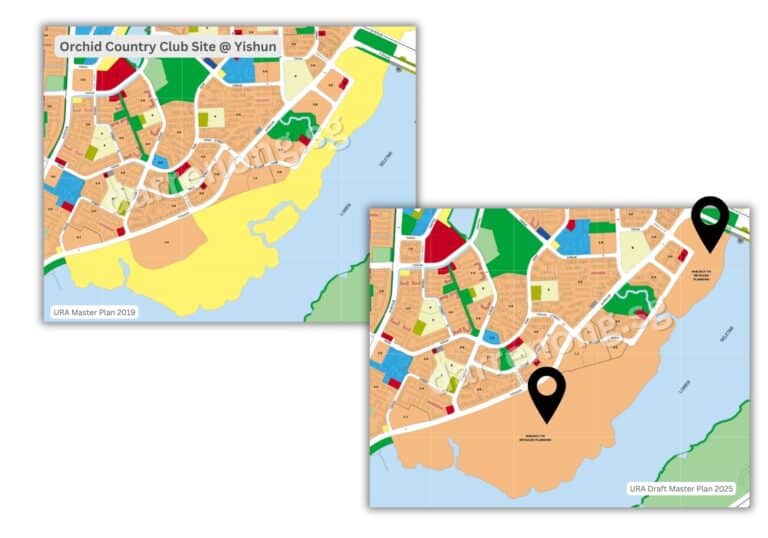
Orchid Country Club – Future Redevelopment Potential
The Orchid Country Club (OCC) site, nestled between Yishun and Lower Seletar, has been identified for future residential development under the Draft Master Plan 2025. While no immediate redevelopment has been announced, the OCC’s eventual transformation is part of Singapore’s longer-term strategy to optimise well-connected land for new homes.
The site offers future potential to evolve into a serene residential enclave with parkland access and waterfront appeal, further enhancing the North’s reputation for nature-rich living.
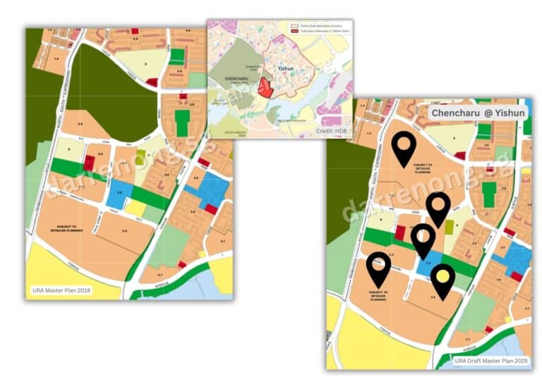
Chencharu – New Integrated Residential District
Chencharu in Yishun is set to become a major new residential precinct, delivering around 10,000 new homes by 2040, with at least 80% being public housing. The first BTO project, launching in 2025, will offer approximately 1,270 units. The estate is envisioned as “A Vibrant Village, Connecting Communities and Heritage,” with a rich tapestry of amenities, green spaces, and heritage features. A colonial-era bungalow from the early 1910s will be retained and adapted for community use in a heritage-themed neighbourhood park, which will also include playgrounds, therapeutic gardens, and a heritage trail.
Chencharu will feature an integrated mixed-use development along a central Community Avenue, housing a new bus interchange, a hawker centre, and retail spaces, forming a lively public hub. The precinct will be supported by amenities such as HomeTeamNS Khatib Clubhouse, Khatib MRT Station, and Lower Seletar Reservoir Park, with further plans for a new educational institution and nursing home to cater to multi-generational needs. Sustainable features such as smart lighting, urban water harvesting, and climate-responsive building orientation will define the estate, while kampung-themed walking and cycling paths will connect residents to Yishun’s broader cycling network and the North-South Corridor.
Economic and Community Hubs
Woodlands Regional Centre will continue to anchor the North’s economic growth, with the development of a major multi-modal transport hub that will seamlessly connect the future RTS Link, MRT, and bus services. This hub will form part of a 7-hectare integrated “business-white” development, blending office, industrial, and retail spaces to support new business models and provide amenities for both workers and residents.
The introduction of more business-white zones in Woodlands will further enhance flexibility, allowing for a dynamic mix of uses and supporting the region’s role as a vibrant economic gateway.
Senior-Friendly and Inclusive Living
The North Region will see the rollout of more community care apartments and assisted-living options, enabling seniors to age in place with dignity and support. Integrated community hubs—combining sports, healthcare, retail, and recreation—will be established in towns like Woodlands, ensuring that amenities are accessible and daily life is convenient for all ages.
Innovation in Land Use and Recreation
Efforts to optimise land use extend underground, with potential caverns at Gali Batu in Woodlands being studied for storage and other uses. At the same time, URA is activating underused spaces, such as MRT viaducts and car park rooftops, for community and recreational purposes.
The region’s extensive green and blue network, including the Greater Rustic Coast—a 50km belt of green nodes and recreational spaces—and the Khatib Nature Corridor, will continue to provide residents with easy access to a wide range of recreational opportunities and nature.
Summary Table: North Region Transformation Highlights
| Neighbourhood / Cluster | Key Features & Plan |
|---|---|
| Kranji (Former Turf Club) | 14,000 new homes; integration with Kranji Nature Corridor; green corridors, lifestyle attractions, equestrian-inspired public spaces, direct MRT links. |
| Woodlands North & Regional Centre | New housing zones; multi-modal transport hub; “business-white” mixed-use development; RTS Link; integrated parks and amenities; cross-border gateway. |
| Sembawang Shipyard | Coastal mixed-use precinct; new homes (number TBC); commercial/recreational spaces; maritime heritage nodes; waterfront promenades. |
| Orchid Country Club (Yishun) | Future residential enclave, parkland, and waterfront access; long-term redevelopment potential. |
| Chencharu (Yishun) | 10,000 new homes by 2040 (80% public); heritage park; mixed-use hub; bus interchange; kampung-themed paths; sustainable features. |
| Economic & Community Hubs | Multi-modal transport hub; “business-white” zones; integrated community hubs with sports, healthcare, retail, and recreation. |
| Senior-Friendly Living | Community care apartments, assisted-living options, and accessible amenities for all ages. |
| Land Use & Recreation Innovation | Underground caverns (Gali Batu); activation of MRT viaducts/car parks for recreation; Greater Rustic Coast; Khatib Nature Corridor. |
North-East Region Transformation: URA Draft Master Plan 2025
The North-East Region is undergoing thoughtful renewal and intensification, with a focus on vibrant townships, new housing precincts, green spaces, and enhanced connectivity. Already home to mature towns like Hougang and Sengkang, and newer districts such as Punggol and Fernvale, the region will continue evolving into a dynamic residential and innovation hub.
With the development of the Punggol Digital District (PDD), upcoming new housing precincts in Defu, and the future relocation of Paya Lebar Air Base, the North-East & East Region is poised to provide liveable, future-ready environments for its growing population. These efforts will be supported by major transport infrastructure enhancements such as the Cross Island Line (CRL) and North-East Line (NEL) extension, ensuring better access and convenience for residents.
Defu & Paya Lebar Air Base – New Housing and Industrial Rejuvenation
Defu is set for a major transformation, with plans to redevelop part of the existing industrial estate into a new residential town. While the exact number and mix of new homes for Defu are still being studied and have not been officially confirmed, the precinct will feature both public and private housing, with essential amenities within a 10-minute walk for future residents. Development will be phased as existing industrial leases expire. The upcoming Defu MRT station will serve the area on the Cross Island Line Phase 1, and it is expected to be completed by 2030. The precinct will also incorporate walking and cycling paths, smart infrastructure, and sustainable features to promote green mobility and community interaction.
The transformation of Defu is closely tied to the future relocation of Paya Lebar Air Base in the 2030s, which will unlock over 800 hectares of land for housing, commercial hubs, and green spaces. As announced in the 2022 National Day Rally by former Prime Minister Lee, the future Paya Lebar township could accommodate up to 150,000 new homes—roughly the combined population of Punggol and Sengkang today. The redevelopment will enable taller buildings in surrounding towns like Hougang and Defu, allowing more efficient land use while preserving heritage and integrating extensive green corridors and community amenities.
Hougang Central – Integrated Regional Centre
Hougang will be enhanced with new housing introduced in pockets near existing amenities and MRT stations. A new Integrated Transport Hub (ITH) at Hougang Central will feature an underground bus interchange, residential units, and retail spaces, seamlessly connecting the North-East Line and Cross Island Line. These upgrades will transform Hougang into a more accessible and vibrant regional centre.
Sengkang & Fernvale – Incremental Growth
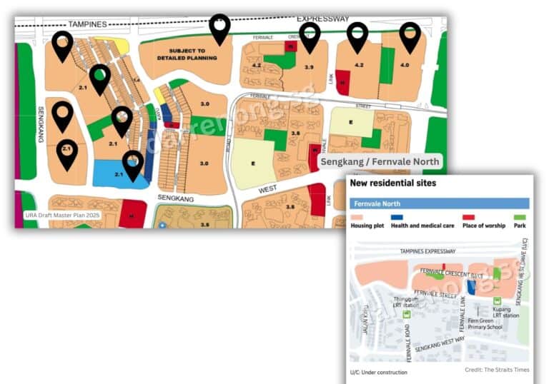
Sengkang continues to mature with new residential areas and amenities aimed at enriching community life. One of the most significant developments is the 18.9-hectare site at Fernvale North, where planning documents suggest space for up to 10,000 new homes—a mix of HDB flats and private residences, supported by parks, places of worship, and healthcare facilities. This development addresses housing demand in the region, especially given the lack of new flats since 2019.
Located near key infrastructure such as Seletar Aerospace Park and Kupang & Thanggam LRT stations, Fernvale North promises a vibrant live-work environment. Comprehensive lifestyle improvements include enhanced park connectors and mixed-use developments that bring community services closer to homes, reinforcing Sengkang and Fernvale as well-connected, family-friendly estates.
Punggol Digital District – Smart Innovation & Waterfront Living
Anchoring the innovation drive in the North-East is the Punggol Digital District (PDD)—Singapore’s first enterprise district that integrates a business park, academic institutions, and residential spaces.
Located next to Punggol Coast MRT Station, PDD will house JTC’s Business Park spaces, the Singapore Institute of Technology (SIT) campus, and various digital and cybersecurity firms. It will offer a live-work-learn-play environment, featuring waterfront promenades, dining outlets, and smart estate features such as centralised logistics and cooling systems.
The integration of residential areas near PDD ensures that professionals and students enjoy convenient access to amenities and recreational options. The district will also be connected to the Round Island Route and Coney Island, encouraging green mobility and active lifestyles.
Riverine Leisure & Recreation – Fun by the Water
The North-East’s riverine corridors—including Sungei Serangoon, Sungei Punggol, and the Lorong Halus area—are being enhanced as vibrant leisure and recreation destinations. The North Eastern Riverine Loop, a 26km scenic park connector linking four major parks, winds through Sengkang and Punggol, offering residents extensive waterfront trails, cycling paths, and lush greenery.
A new 20-hectare riverine park in Sengkang will integrate with existing natural vegetation along Sungei Punggol, providing spaces for relaxation, nature appreciation, and community gatherings. Across the region, park connectors are being extended and new green links established to bring residents closer to parks and waterways.
These efforts align with Singapore’s Recreation Master Plan and the City in Nature vision, aiming to activate green and blue spaces for wellness, active lifestyles, and social interaction. Residents can expect more water play areas, lookout points, therapeutic gardens, and multi-functional communal spaces along waterways. By 2030, Singapore aims to have 500km of park connectors islandwide, with more than 25 new parks and over 50km of new connectors completed between 2025 and 2030.
Enhancing Connectivity
Connectivity in the North-East will be significantly enhanced by the Cross Island Line (CRL) and North-East Line (NEL) extension, providing seamless MRT access to new and established neighbourhoods including Defu, Hougang, Sengkang, and Punggol. These rail improvements will be complemented by upgraded bus interchanges and integrated transport hubs, such as the new Hougang Central ITH, ensuring efficient transfers and convenience.
Active mobility will be a key focus, with expanded park connectors and cycling paths linking homes, parks, waterfronts, and transport nodes. These routes will support last-mile connectivity, encourage car-lite lifestyles, and ensure that every household is within a 10-minute walk from a park or green space.
The enhanced transport and active mobility networks will not only improve access to recreational and natural amenities but also promote healthier, more sustainable urban living in line with Singapore’s City in Nature goals.
Community, Green, and Inclusive Living
The North-East Region will benefit from new integrated community hubs in Sengkang and Punggol, combining sports, healthcare, retail, and social spaces for vibrant neighbourhoods. More senior-friendly housing and assisted living options will be incorporated into new estates, supporting ageing-in-place with dignity and care.
URA is also activating underused spaces such as MRT viaducts and HDB rooftops for community and recreational use, enhancing social interaction and inclusivity. Heritage and sustainability remain central to planning, balancing growth with preservation of identity and natural assets.
Summary Table: North-East Region Transformation Highlights
| Neighbourhood / Cluster | Key Features & Plan |
|---|---|
| Defu | New residential town with public and private housing (number to be confirmed); served by CRL Defu MRT station; smart, green, live-work-play integration. |
| Paya Lebar Air Base | 800+ ha land unlocked; potential for up to 150,000 new homes; commercial hubs, green spaces; taller buildings in Hougang/Defu; heritage and sustainability focus. |
| Hougang Central | New Integrated Transport Hub (ITH) with underground bus interchange, homes, retail, seamless NEL and CRL connectivity. |
| Sengkang & Fernvale | Up to 10,000 new homes at Fernvale North; parks, healthcare, worship, enhanced park connectors; family-friendly, well-connected estates. |
| Punggol Digital District | JTC Business Park, SIT campus, digital/cybersecurity firms; live-work-learn-play; waterfront promenades; smart estate features; connected to Round Island Route and Coney Island. |
| Riverine Leisure | North Eastern Riverine Loop; new riverine parks; extended park connectors; water play, lookout points, therapeutic gardens. |
| Connectivity | CRL, NEL extension, upgraded bus interchanges; expanded cycling/walking networks; last-mile connectivity; car-lite lifestyle support. |
| Community & Green Hubs | Integrated community hubs, senior-friendly and assisted living housing, activation of underused spaces, heritage, and sustainability focus. |
West Region Transformation: URA Draft Master Plan 2025
The West Region continues to be a strategic focus for Singapore’s long-term urban and economic development, serving as a cornerstone of the URA Draft Master Plan 2025. Building upon the foundations laid in the 2019 Master Plan, the latest draft brings a sharpened emphasis on decentralisation, mixed-use integration, sustainable living, and economic resilience. As part of the nation’s future-ready vision, the West is set to evolve into a vibrant, integrated hub where housing, innovation, green spaces, and connectivity converge seamlessly.
This next phase of transformation brings both continuity and enhancement to key precincts—including Jurong Lake District, Jurong Innovation District, Tengah, and Tuas Port—through new planning tools, greater zoning flexibility, and community-centric features. By supporting the decentralisation of economic activity and thoughtfully weaving homes, jobs, and amenities into the urban fabric, the West Region transformation ensures that residents also get to enjoy a higher quality of life and that Singapore’s growth remains balanced, sustainable, and resilient for generations to come.

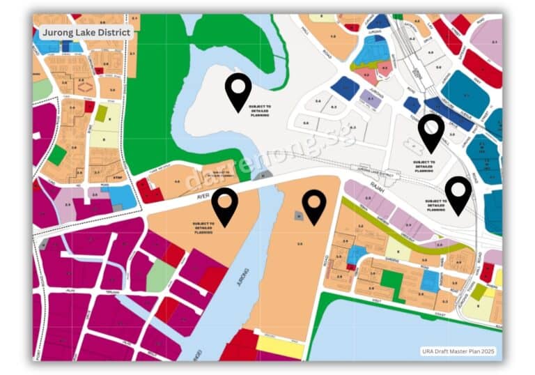
Jurong Lake District (JLD): From Vision to Implementation
Jurong Lake District (JLD) was already positioned in the 2019 Master Plan as Singapore’s largest mixed-use business district outside the city centre, with a focus on quality offices, homes, amenities, and green spaces. The 2025 Draft Master Plan reaffirms JLD’s role but introduces greater flexibility and responsiveness to market conditions. The minimum office quantum for the master developer site has been reduced, giving developers more latitude in the mix and pacing of uses.
There is a stronger push for “business-white” zones—allowing more non-industrial uses and potentially even housing or hotels if industrial disamenities can be managed. Enhanced transport integration is now a clear focus, with the Jurong East Integrated Transport Hub and new MRT lines (Jurong Region Line, Cross Island Line) being phased in to support the district’s growth.
The redevelopment of the former Jurong Bird Park and Jurong Hill is now more closely tied to JLD’s ecosystem, with innovation-driven industries, startup incubators, and urban agriculture proposed for the 39ha site. The vision is for JLD to support over 100,000 jobs, deliver new homes, and offer a vibrant lakeside environment for work, leisure, and community life.
Jurong Innovation District (JID): Advanced Manufacturing and Innovation Hub
JID was conceived as a next-generation industrial park in 2019, clustering advanced manufacturing, R&D, and training institutions (including NTU) to drive Industry 4.0 and test-bed urban solutions. The 2025 Draft Master Plan expands JID’s role as a core node in the “Western Gateway,” with more “business-white” zoning to accommodate new business models, co-working, and even non-industrial uses.
While JID will feature supporting amenities and green connectors, integrated community hubs combining sports, healthcare, retail, and social spaces are primarily planned for new residential areas and regional centres in the West Region, such as Tengah and Jurong Lake District. JID’s focus remains on fostering a vibrant innovation ecosystem with strong links to surrounding communities and transport infrastructure to attract global talent and support a liveable environment.
Tengah: Scaling Up Smart, Sustainable Living
Tengah was introduced as Singapore’s first “Forest Town” in the 2019 Master Plan, with a car-lite town centre, five distinct residential districts, and a focus on smart, sustainable living. The 2025 Draft Master Plan will further enhance Tengah’s role as a model for eco-friendly urban development, with plans for a full build-out of around 42,000 new homes.
There is a renewed focus on integrating Tengah with the broader Western Gateway, including seamless connections to JLD, JID, and new transport lines. New amenities, schools, and community facilities are being phased in, and the plan continues to push for innovative urban solutions, such as district cooling, smart lighting, and extensive active mobility networks. Tengah’s development is also being paced to respond to housing demand and changing lifestyle needs, with the first wave of residents having moved in from late 2023.
More New Homes in Established Towns In The West
Beyond Tengah, established towns such as Bukit Batok, Choa Chu Kang, Clementi, Jurong East, and Jurong West will undergo rejuvenation and see new housing plots introduced. The plan emphasizes integrating homes with transport nodes, amenities, and green spaces, ensuring residents enjoy a high quality of life with easy access to jobs, schools, healthcare, and recreation.
The introduction of more flexible “business-white” zoning in areas like Jurong and Tuas industrial estates could also allow for housing to be integrated if industrial disamenities can be managed, optimizing land use and injecting amenities for both workers and residents.
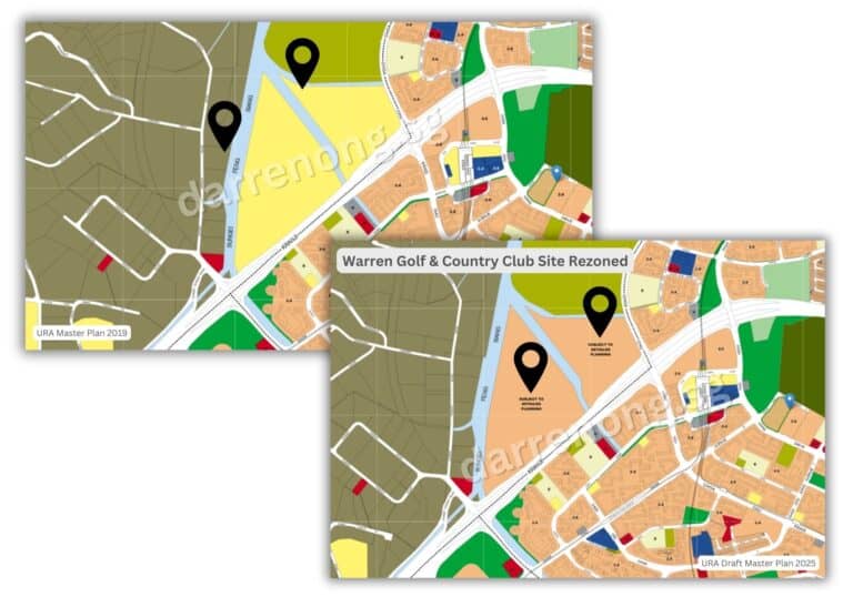
Warren Golf & Country Club Site Rezoned
Redevelopment of Jurong Bird Park & Jurong Hill
The redevelopment of the former Jurong Bird Park and Jurong Hill will further support the growth of the western gateway, potentially bringing new amenities, jobs, and residential options to the greater Jurong area. An ideas competition for the 39-hectare site has generated proposals for innovation-driven industries, startup incubators, agricultural R&D, and integrated commercial and recreational spaces, all of which will enhance the vibrancy of the region.
Tuas Port: From Vision to Mega-Port Reality and Beyond
The vision for Tuas Port was first officially announced in 2012 as part of Singapore’s long-term maritime strategy, with construction commencing in 2015. The first berths became operational in 2021, and the port was formally inaugurated in September 2022. Tuas Port will be developed in four phases, consolidating all container operations from Tanjong Pagar, Keppel, Brani, and Pasir Panjang terminals by the 2040s1238.
When fully completed, Tuas Port will have 66 berths, handle up to 65 million TEUs annually, and be the world’s largest fully automated container terminal, powered by advanced automation, AI, and green technologies. This consolidation will not only enhance Singapore’s supply chain resilience and global maritime competitiveness but also free up more than 1,000 hectares of prime southern waterfront land for redevelopment1238.
The Draft Master Plan 2025 lays out the next chapter for these vacated city port sites: the creation of the Greater Southern Waterfront (GSW). This future district will stretch from Pasir Panjang to Marina East and feature new waterfront homes, offices, parks, and lifestyle destinations, transforming Singapore’s cityscape and bringing new vibrancy to the southern coast. Tuas Port’s scale and technological sophistication will anchor new maritime, logistics, and supply chain industries in the West, supporting job creation, economic resilience, and Singapore’s net-zero ambitions through electrified operations and smart, sustainable infrastructure.
Green & Blue Networks – City in Nature
Green living and recreation are central to the West’s transformation. By 2030, the region will benefit from more than 25 new or upgraded parks and an expanded network of over 50km of park connectors, including enhancements to the Kranji Nature Corridor and Jurong Lake Gardens. These initiatives support Singapore’s “City in Nature” vision, promoting biodiversity, outdoor leisure, and urban resilience. The Rail Corridor (West), new nature ways, and adventure loops will further enhance connectivity and access to nature for all residents.
Transport & Connectivity
By 2035, the West will be served by six rail lines, including the Jurong Region Line and Cross Island Line, connecting residents to key employment, recreation, and leisure areas. The future Jurong East Integrated Transport Hub will allow seamless transfers between MRT lines and bus services, adding vibrancy and convenience to the area. Active mobility corridors and expanded cycling networks will make it easier for residents to travel within the West and access parks, schools, and commercial centres.
The transformation of Singapore’s West Region under the URA Draft Master Plan 2025 exemplifies the city-state’s forward-thinking approach to urban development. By integrating new and rejuvenated housing, business and innovation hubs, and extensive green networks, the West is poised to become a model for sustainable and inclusive growth. These initiatives demonstrate how regional planning is central to Singapore’s broader ambition: building a resilient, liveable, and globally competitive city for generations to come.
Summary Table: West Region Transformation Highlights
| Neighbourhood / Cluster | Key Features & Plan |
|---|---|
| Jurong Lake District | Mixed-use business district; integrated transport hub; offices, retail, leisure; seamless connectivity to city and Malaysia. More new homes will be planned. |
| Tengah Estate Transformation | Forest Town: five residential districts; car-lite, green corridors; smart and sustainable features; new amenities and schools. The 2025 Draft Master Plan will further enhance Tengah’s role as a model for eco-friendly urban development, with plans for a full build-out of around 42,000 new homes. |
| Jurong Innovation District & Economic Hubs | Advanced manufacturing hub; R&D, tech businesses; collaboration with NTU; new homes for workers and students planned, exact numbers to be confirmed; supporting amenities and green connectors. |
| Tuas Port | World’s largest automated port; consolidates Tanjong Pagar, Keppel, Brani, and Pasir Panjang terminals; supports logistics, manufacturing, and frees up city land for redevelopment; enables the Greater Southern Waterfront. |
| Warren Golf & Country Club Site Rezoned | 51-ha site in Choa Chu Kang rezoned for future residential and mixed-use development after lease expiry in 2030; close to transport nodes and park connectors; adds to housing and community facilities. |
| Bukit Batok, Bukit Panjang, Choa Chu Kang, Clementi | Upgrading and renewal of existing towns; more homes near transport nodes and parks. |
| Redevelopment of Jurong Bird Park & Jurong Hill | 39-ha site for innovation-driven industries, startup incubators, urban agriculture, and integrated commercial and recreational spaces; potential for new amenities, jobs, and homes. |
| Green & Blue Networks | 25+ new/upgraded parks; 50km park connectors; Jurong Lake Gardens; Rail Corridor (West); nature ways and adventure loops. |
| Transport & Connectivity | 6 rail lines by 2035; Jurong East Integrated Transport Hub; active mobility corridors; expanded cycling and walking networks. |
More Sites Across Singapore Rezoned for Housing
Besides the major transformation areas and new towns highlighted in the URA Draft Master Plan 2025, we also see more sites across Singapore being rezoned for housing. This move is unlocking a pipeline of new homes by intensifying land use in both established and emerging neighbourhoods. Such strategic rezoning will inject fresh housing supply into mature and growth areas, supporting diverse housing needs and enhancing community vibrancy.
Key sites identified for new housing include:
Toa Payoh Rise / Toa Payoh Link and Lorong 4 Toa Payoh:
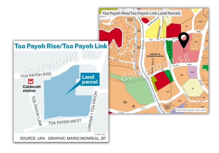
Additionally, a nearby parcel along Lorong 4 Toa Payoh with a proposed plot ratio of 3.4 is being considered for residential development, which could add another 200 to 350 new homes.
Upper Thomson Road Land Parcel:
Land parcels along Upper Thomson Road, located near Marymount MRT station, are set to be redeveloped for residential use under the URA Draft Master Plan 2025. This well-connected area offers excellent transport links, providing residents with seamless access to the city centre and other parts of Singapore via the Circle Line and nearby bus services.
The potential housing yield for this site is significant. If developed as private housing, it could accommodate approximately 2,200 to 2,300 condominium units. Alternatively, if planned for public housing, the site could provide around 1,500 to 1,600 HDB flats. This flexibility allows for a diverse mix of housing options to cater to different needs and preferences.
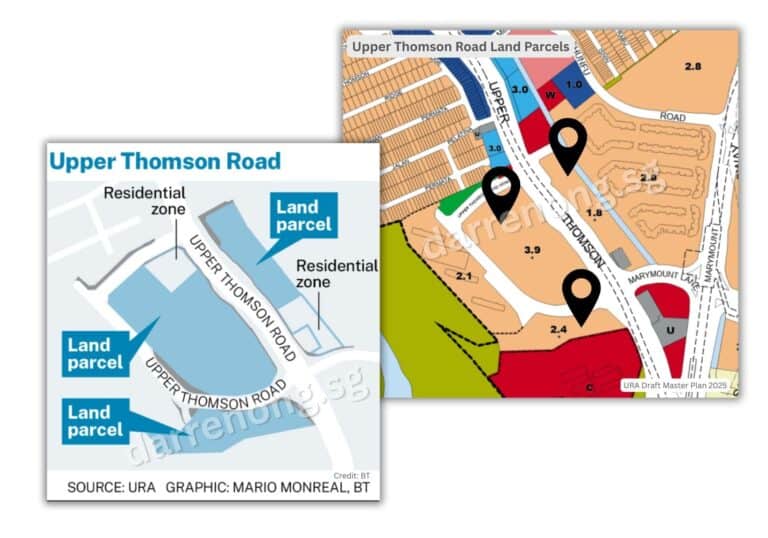
Residents in this area will enjoy proximity to a wide range of amenities, including schools, parks, dining establishments, and the scenic MacRitchie Reservoir. The redevelopment is expected to enhance the vibrancy of the Thomson corridor and contribute to the rejuvenation of the surrounding neighbourhoods.
With its strategic location, comprehensive amenities, and strong transport connectivity, the Upper Thomson Road site is poised to attract families, young couples, and professionals seeking quality city-fringe living. This new residential cluster will further strengthen Upper Thomson’s reputation as a desirable and convenient place to live.
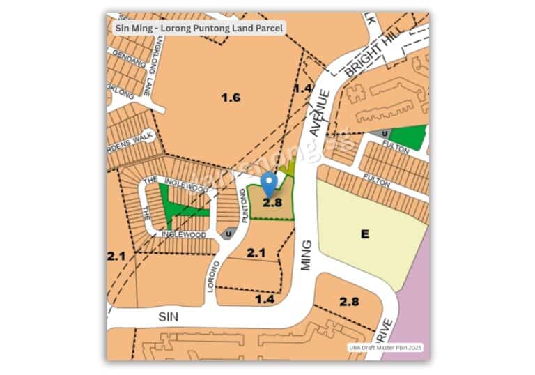
Sin Ming Area – Lorong Puntong Land Parcel:
A plot of land at Lorong Puntong in the Sin Ming area is set to be developed into new homes, adding to the growing residential options in the Thomson/Bishan corridor. The site, spanning just over 4,000 square metres, is located near established condominiums such as Thomson Impressions and The Gardens at Bishan. It offers convenient access to amenities, reputable schools, parks, and public transport, including the nearby Bright Hill MRT station on the Thomson-East Coast Line.
Market analysts estimate that this site could yield approximately 130 to 150 condominium units, providing more housing choices for buyers seeking city-fringe living with strong connectivity and lifestyle conveniences.
Tampines Street 11 Land Parcel:
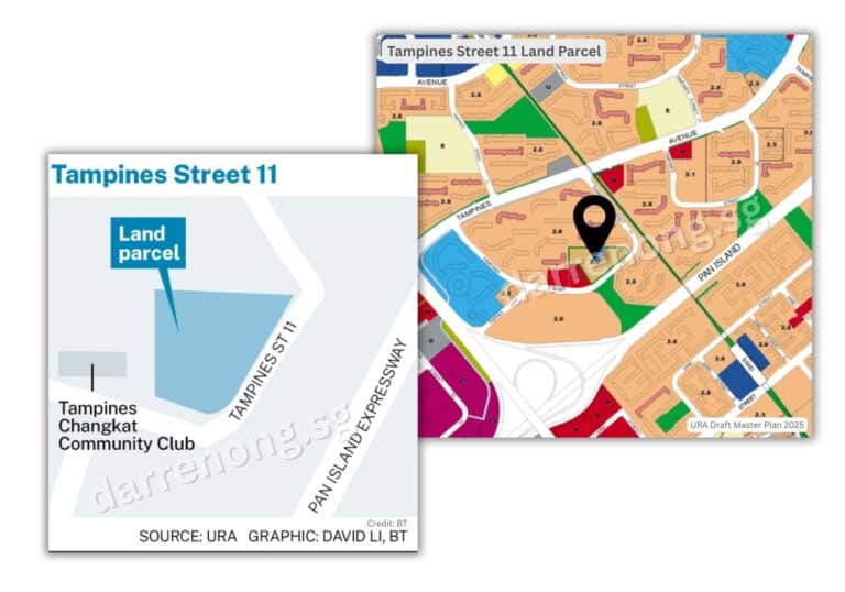
This location is near Treasure at Tampines, one of Singapore’s largest condominium developments with 2,203 units across 29 blocks. Treasure at Tampines has enjoyed remarkable sales success since its launch, reflecting strong demand for quality homes in the area. Residents of the new Tampines Street 11 development will also benefit from proximity to a wide range of amenities, including the popular Tampines Round Market & Food Centre, major shopping malls, and convenient access to transport links, making it a vibrant and well-connected place to live.
Pasir Ris Drive 3/Drive10 Land Parcel:
A major new residential site is coming up at the intersection of Pasir Ris Drive 3 and Pasir Ris Drive 10, set to be rezoned for housing with a proposed gross plot ratio of 3.2. This large parcel is expected to be released under the Government Land Sales (GLS) programme and could potentially yield over a thousand condominium units.
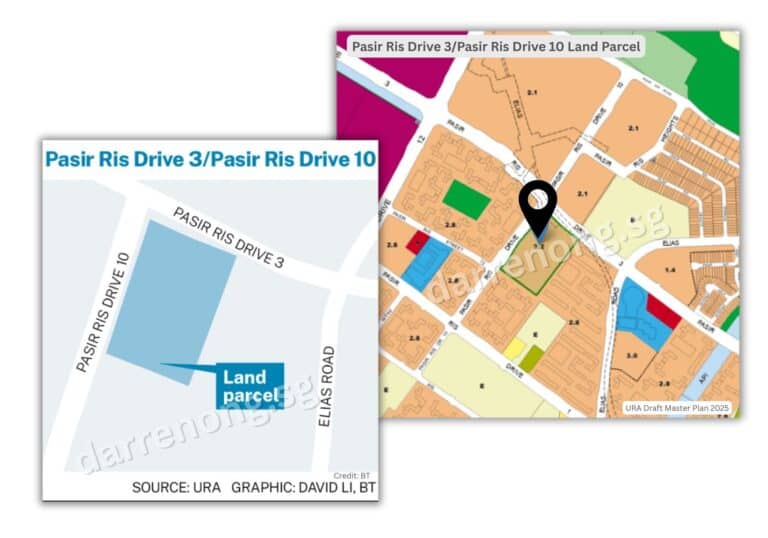
This development is especially notable as it marks the first GLS site for private condominium housing in Pasir Ris since 2012, meeting pent-up demand for new private homes in the East. The site’s strategic location offers residents easy access to established amenities, parks, and schools, as well as convenient transport connections.
Importantly, the parcel is located very close to the upcoming Elias MRT station on the Cross Island Line, which will provide future residents with excellent connectivity to the rest of Singapore. With its family-friendly environment, proximity to green spaces, and strong transport links, the new development at Pasir Ris Drive 3 and Pasir Ris Drive 10 is set to attract both homeowners and investors looking for quality living in a well-connected neighbourhood.
Bedok South Road Land Parcel:
Bedok South Road is set to welcome more new homes as part of Singapore’s ongoing efforts to rejuvenate mature estates and optimize land use. The land parcel—previously occupied by schools—is expected to be rezoned for residential development. In addition, an adjacent plot will see its gross plot ratio increased, allowing for higher-density housing and more efficient land use.
According to market analysts, the combined redevelopment of these sites could yield about 1,000 to 1,100 condominium units if developed as private housing, or approximately 700 to 800 HDB Standard flats if planned for public housing. This flexibility gives planners the option to tailor the housing mix to meet evolving demand and community needs.
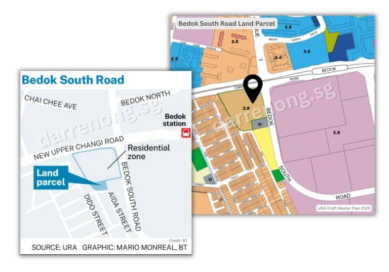
The Bedok South Road site enjoys a prime location within a well-established neighbourhood, offering residents access to a wide range of amenities such as Bedok Mall, Bedok Town Centre, and various schools and parks. The area is also well-served by public transport, with Bedok MRT station nearby, ensuring convenient connectivity to other parts of Singapore.
With its strategic location, established amenities, and strong transport links, the new development at Bedok South Road is poised to attract both families and professionals seeking quality homes in a mature and vibrant community. This upcoming project will further enhance Bedok’s reputation as one of Singapore’s most liveable and sought-after heartland estates.
Sunbird Avenue, Simei Road, and Upper Changi Road Land Parcel:
Land parcels at Sunbird Avenue, Simei Road, and Upper Changi Road are set to be redeveloped into new residential projects, introducing more homes and amenities to the well-established Upper Changi neighbourhood. Previously zoned for educational use, these sites have been earmarked for residential development to address growing housing demand and make better use of land in the East.

The area stands out for its close proximity to Upper Changi MRT station on the Downtown Line, offering residents direct and convenient access to the rest of Singapore. Residents will also benefit from nearby amenities such as Changi City Point, Singapore Expo, SUTD (Singapore University of Technology and Design), Changi Business Park, and various recreational facilities, making it a highly convenient and vibrant place to live.
For investors, this land parcel presents strong potential due to its location within a mature suburban estate that is well-served by transport and infrastructure. The proximity to educational institutions and major business hubs supports steady rental demand from both local and expatriate tenants, while ongoing enhancements in the area are likely to contribute to long-term capital appreciation. As the Upper Changi precinct continues to evolve, new residential developments here are well-positioned to attract both homeowners and investors seeking value and connectivity in Singapore’s East.
Brickland District Transformation:
The Brickland District in Tengah Town is set for significant transformation as part of ongoing plans to develop Singapore’s western region. Several land parcels within this district will be redeveloped to create a vibrant, integrated community. The plans include not only new housing sites but also a comprehensive mix of parks, places of worship, health and medical care facilities, educational institutions, and civic and community institutions.
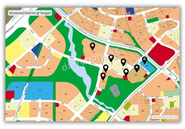
This holistic approach aims to foster a well-balanced living environment, supporting both the daily needs and overall well-being of future residents. The integration of green spaces and community amenities reflects Tengah’s vision as Singapore’s next-generation “Forest Town,” prioritizing sustainability, connectivity, and quality of life.
With these upcoming developments, Brickland District is poised to become a key residential and lifestyle hub in the West, attracting families, professionals, and investors looking for modern homes with access to a full spectrum of amenities and services.
Conclusion: A Glimpse into Singapore’s Future Urban Landscape
Singapore’s Draft Master Plan 2025 reflects a bold and comprehensive approach to sustainable urban growth, decentralisation, and housing affordability. By unlocking new land parcels and rejuvenating existing districts across all five regions—Central, East, West, North, and North-East—the plan offers not just more homes, but smarter, greener, and better-connected communities for future generations.
For homeowners, investors, and real estate observers, the Master Plan unveils where the next wave of transformation will take shape. From the forest-lined smart town of Tengah and the visionary Greater Southern Waterfront, to the game-changing redevelopment of Paya Lebar Air Base and the rise of Tuas Port as a next-generation logistics hub, the opportunities are wide-ranging and strategically placed.
Other upcoming precincts will reshape Singapore’s residential landscape significantly. The former Bukit Timah Turf City will evolve into a heritage-inspired hillside community with 15,000 to 20,000 homes. Kranji Racecourse (Singapore Turf Club) will be reimagined as a rustic-themed township offering around 14,000 homes, nestled beside nature corridors and MRT infrastructure. The Marina Bay Golf Course site, following the expiry of its lease in 2024, has been identified for future transformation into a mixed-use waterfront district in the city centre, unlocking one of the last major undeveloped parcels in the Marina Bay area.
Meanwhile, innovation-centric zones such as Greater One-North and Dover Medway will see thousands of new homes integrated with research institutions, tech campuses, and eco-friendly green links. The Sembawang Shipyard precinct will be transformed into a coastal residential and lifestyle destination, honouring its maritime legacy while providing modern living by the sea.
In the North-East, Springleaf Estate and Lentor Estate will welcome new housing thoughtfully integrated with MRT connectivity and greenery, offering a serene yet accessible alternative to city living. At the same time, underutilised land from various golf courses and country clubs, including Orchid Country Club, Warren Golf & Country Club, and others, will be progressively rezoned for future residential use, ensuring long-term housing supply in well-connected neighbourhoods.
Whether you’re looking to invest, upgrade, or understand how Singapore’s cityscape will evolve, keeping an eye on these transformation clusters is key. As infrastructure, transport networks, and mixed-use precincts take root, the long-term value potential in emerging and rejuvenated areas could be significant. Singapore’s Master Plan 2025 is not just about zoning—it’s a forward-looking vision to build a resilient, liveable, and inclusive city for generations to come.
Looking Ahead? Let’s Talk.
If you’re planning your next move or simply want to understand how these transformation zones could impact your property goals, feel free to reach out. I’m always happy to chat and share insights—no pressure, just a real conversation about what’s ahead for Singapore’s evolving landscape.
Need Real Estate Consultation?
Contact Me
Feel free to connect with me!

Group District Director
Huttons Asia Pte Ltd
CEA Registration No.: R026434F
Agency License: L3008899K
Contact: 93839588
Singapore New Launch Condos 2026: Where the Next Property Opportunities Are Emerging
Discover Singapore new condo launches in 2026, upcoming projects, supply trends and property market outlook to help buyers and investors make informed decisions.
How Property Loan Strategies Help Singapore Investors Improve Cash Flow and ROI Through Smart Leverage
Learn how property loans and leverage help Singapore investors improve cash flow, boost ROI, and build long-term wealth with smarter financing strategies.
Where Can You Find and How to Buy an Upcoming Executive Condominium (EC) in 2025
Buying Exec Condo EC Guides 2025. Upcoming Otto Place EC at Tengah. Aurelle of Tampines 晶莹轩 EC at Tampines St 62. Other Available New Launch EC. Altura EC 雅乐轩, North Gaia EC, Lumina Grand EC 昱丰嘉园. Purchase Procedures Guides Available.
Understand Property Wealth Planning
Ever heard of the term ‘Property Wealth Planning’ (PWP) and wondered what it means? Well, you’re not alone. Let’s dive in and understand the strategy.

Singapore URA Draft Master Plan 2025: New Housing Clusters, Land Rezoning & Key Transformation Areas Announced
Explore Singapore’s Draft Master Plan 2025 — featuring new housing clusters, rezoned land parcels, and major transformations across Bukit Timah Turf City, Kranji Racecourse, Greater One-North, and the Greater Southern Waterfront.

What You Need to Know About Sales Proceeds After Selling Your Property
What You Need to Know About Sales Proceeds After Selling Your Property. Proper property financial calculations are crucial, and overlooking any costs can lead to unexpected financial shortfalls